24. Was the Capitol Built on an Ancient Site?
- M Campbell
- Mar 2, 2021
- 18 min read

Updated: Sep 28, 2024

The United States Capitol building, in Washington,D.C., is one of the most iconic buildings in the world. As it has been home to the congress since 1800, it is, culturally, politically and historically, perhaps the most important building in the United States. The man who designed the city of Washington, Pierre Charles L'Enfant, was also expected to design the Capitol building. While he chose the spot, which he described as a “pedestal waiting to happen”, his temper got the better of him, and he refused to work with the local commissioners, so he got the sack. What did L'Enfant mean by a pedestal waiting to happen? Presumably he was referring to the slightly elevated position of what is now called Capitol Hill, referred to by L'Enfant as Jenkins's Hill? Or was there something else? Perhaps one of the many Native American mounds that were so common in those days all across the United States?
Many places sacred to Native American people may be part of long-distance alignments. Curiously, several important political and financial centres in the States are also to be found as part of the same alignments. In particular, a line between the Pyramid of the Sun at Teotihuacan, in Mexico, and the Statue of Liberty in New York, skirts Stone Mountain, a place sacred to Native Americans, and goes right through the Capitol building in Washington D.C., and the city of Philadelphia. Why do many of the most important cities on the east coast of the USA seem to form a line, and why are some pre-Columbian sacred sites also on this line? Why was the Capitol built on an alignment that included pyramids and sacred natural places?

This alignment may be pure coincidence, but it does exist. It can easily be checked on Google Earth: starting at the pyramid of Cuicuilco in Mexico, a line drawn with the ruler function to the Temple of Quetzalcoatl, at Teotihuacan, also in Mexico, shows an azimuth of 39.66 degrees and a distance of 34.09 miles. Prolonging this ling to Stone Mountain, in the USA, the azimuth is still 39.66 degrees for the western end of the rock, and 39.67 for the eastern end, at a distance of 1361.69 miles. Prolonging the line still further from Cuicuilco to the Capitol in Washington D.C., the azimuth is 39.66 degrees to the centre of te building, and 39.67 to the south east section of the building, and the distance is 1892 miles. Cuicuilco to Philadelphia, specifically the outskirts of the town, on the Schuylkill River Trail, near the Jefferson University East Falls Campus, the azimuth remains 39.66 degrees and the distance is 2015.94 miles (specifically this point is at the phi point between the Statue of Liberty and the Capitol). The line drawn from Cuicuilco to the Statue of Liberty is 2092.73 miles long, and has an azimuth of 39.67 degrees to the statue itself, and 39.66 to the museum on the island.
Cuicuilco was once located on the southern shore of the now dry Lake Texcoco. It was also once a major city, but was destroyed by a volcano, Xitle, in the first century BC. If Cuicuilco is part of an alignment, then the alignment itself must therefore be older than two thousand years.

As we have seen. a line drawn from Cuicuilco to the Capitol in Washington D.C. goes straight through the Temple of the Feathered Serpent at Teotihuacan. Teotihuacan is probably the most important archaeological site in Mexico, it was once the largest city in the pre-Columbian Americas. It is known for its pyramids and the Avenue of the Dead which links them. The city's name is supposed to derive from "birthplace of the gods", or "place where gods were born" (1), which suggests that the location was important for more than practical reasons.


The next point on the line drawn is Stone Mountain, in Georgia, a huge slab of granite sacred to Native Americans, but famous now also for the largest bas-relief sculpture in the world, the Confederate Memorial Carving, which depicts three Confederate leaders of the Civil War: President Jefferson Davis and Generals Robert E. Lee and Thomas J. "Stonewall" Jackson. It is associated with the Ku Klux Klan and is seen by many as a shrine to white supremacy. There is talk of removing the sculptures. When the mountain was first encountered by European explorers, its summit was encircled by a rock wall, similar to that still to be found on Georgia's Fort Mountain. The wall is believed to have been built by early Native American inhabitants of the area, Cherokee, Creek and Muscogee The mountain was the eastern end of the Campbellton Trail, a Native American path that ran through what is now the Atlanta area.
Before 1800, Native Americans used the mountain as a meeting and ceremonial place. Archaeological evidence goes back 9,000 years. In the late 17th century, when European settlers started to arrive in big numbers, they brought disease with them killing thousands of locals, who would meet up at Stone Mountain to think of ways to overcome the situation. In response to the threat posed by contact with the immigrants, surviving indigenous tribes made alliances with one another during the late eighteenth century. These alliances became known as the Creek Confederation. Two major trails connected it to the eastern part of the state. Every year there's a Native American Festival and Pow-Wow.
In Europe, when the early Christians took over pre-Christian sites for their own use, despite the violence shown to non-Christian people, they took care to preserve the importance of the sites, but on their own terms, under a new banner. In a similar way, extreme right-wing people took over this hugely important native American site, simultaneously vandalising and glorifying it. It seems to be a natural reaction that incoming invaders have, to take possession, in both destructive and creative ways, of crucial points on the land. Perhaps it is simply a reflection of Stone Mountain's status to the native inhabitants of the land that it became so important to their enemies.

Next on the line, after passing just three miles from Monticello, Jefferson's home, is the Capitol itself.

It's impossible to know for sure whether the site of the Capitol was an important site prior to the immigration wave from Europe. There are many examples of important religious and political sites being placed on the exact spots of the temples and towns of vanquished peoples, notably in Europe, where many christian churches and cathedrals were built on the sites of pagan temples. it's another matter altogether to find proof of anything more than a settlement at the Capitol. There are some vague references to Native Americans having had sites on "modern-day spots like the White House and Capitol Hill", but only mentions of pot shards and other finds on the grounds of the White House.
An article in the Washington Post says "The Nacotchtank tribe in the early 1600s had about 300 members who lived in villages, mostly along the eastern banks of what is now the Anacostia River, before merging with other tribes in the early 1700s." and that "Samuel Vincent Proudfit, an archaeologist who worked with the Interior Department in the 1800s, found signs of the tribe’s existence in the remains of a village near Garfield Park, between First and Second streets SE on Capitol Hill."(2)
Indeed, the the Nacotchtank are an indigenous people who lived in the area of what is now Washington, D.C. at least up until the 17th century. These people were forcibly removed to make way for tobacco plantations, and for a time, took refuge on what is now Theodore Roosevelt Island, before disappearing altogether. The Nacotchtank were known as traders and had their headquarters along the intersection of two major rivers, the Potomac and the Anacostia. Archaeologist Samuel Proudfit has found evidence of Nacoctchtank occupation where the White House swimming pool was built and on Capitol Hill, amongst several other places in the District of Columbia. (3) Perhaps we will never know what the hill on which the Capitol was built might once have represented or whether it was natural or man-made. As one article (whitehousehistory.org) puts it: "Unfortunately, the rapid and continuous development of Washington, D.C. over the past two centuries disrupted much of the region’s archaeology and little effort was made to record the extensive evidence that once existed. "(4) There is now an app you can download called "Guide to indigenous D.C. Guide to Indigenous DC on the App Store (apple.com)

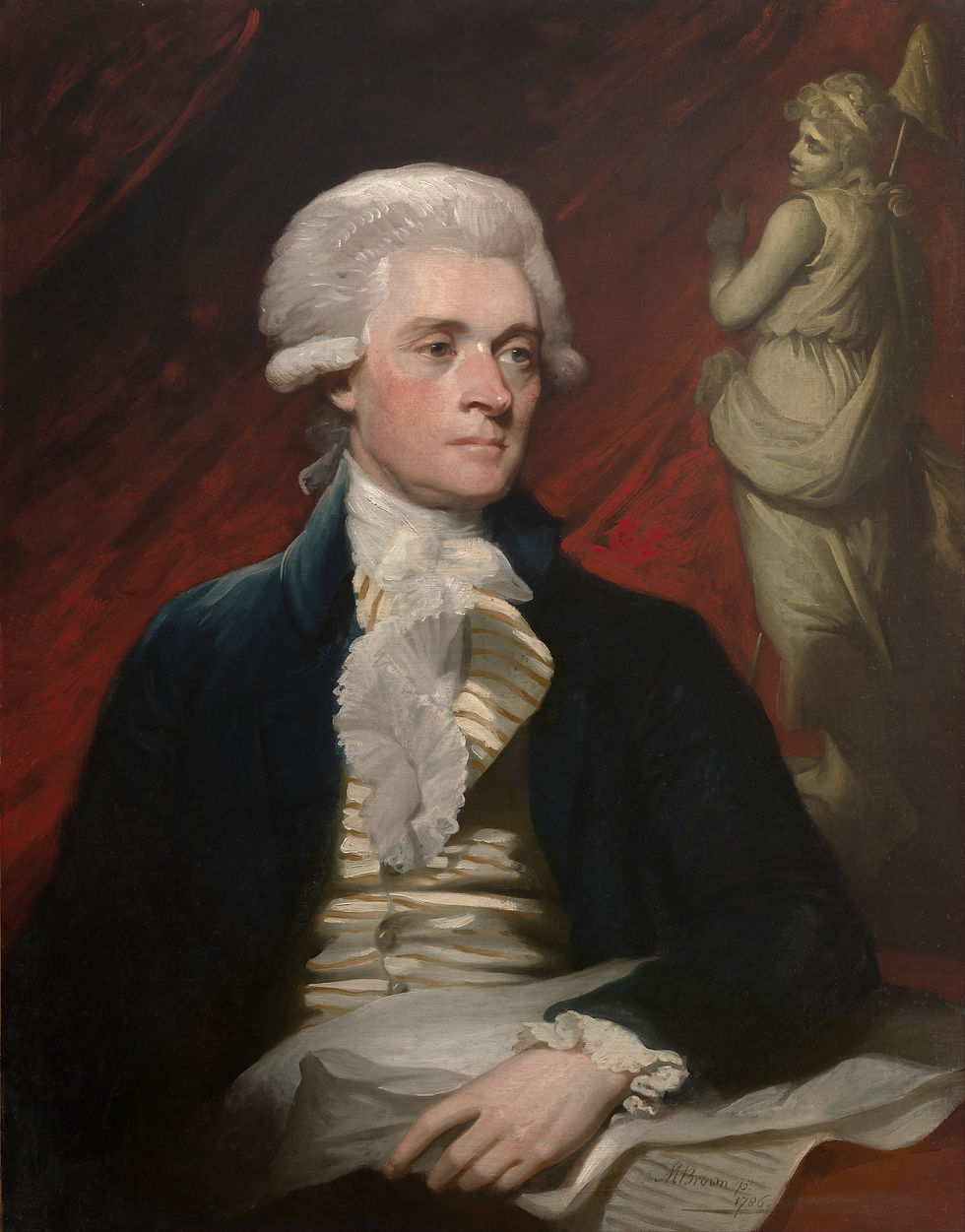
In the Declaration of Independence, Jefferson writes, seemingly without irony, about "the merciless Indian Savages, whose known rule of warfare, is an undistinguished destruction of all ages, sexes and conditions." Yet, despite these harsh words, and apparent lack of empathy for those defending their lives and their homeland, Jefferson was not without sympathy for the ancient cultures he found traces of in America. He apparently personally excavated a Native American mound on his land at Monticello. Jefferson was among those who chose developed the site that would become Washington D.C.. If the Capitol building had been built on a site sacred to the Native people, would Jefferson have known about it? It is curious that Jefferson's image is carved onto Stone Mountain, that he was part of the process of designing Washington DC and the Capitol, and that the alignment mentioned earlier goes through a university campus that bears his name in Philadelphia. It is also interesting that his home of Monticello was near this alignment.
The hill the Capitol was built on was in fact selected by Pierre Charles l'Enfant, who was in regular correspondence with Jefferson. Wikipedia says the site was already called Jenkins Hill, but this article suggests otherwise:
Quote The Mysterious Mr. Jenkins of Jenkins Hill: The Early History of the Capitol Site JOHN MICHAEL VLACH The ground on which the United States Capitol stands was known from the earliest moments of European settlement as the New Troy tract. Granted in 1663 by the second Lord Baltimore to George Thompson, it was one of three substantial parcels that Thompson would own within the boundaries of the future District of Columbia. His holdings encompassed some 1,800 acres, or slightly more than one-fourth of all the land that would be allotted for the site of the capital city. While the 500 acres that constituted New Troy would change hands six times, it was never known by any other name prior to 1791. When Daniel Carroll of Duddington finally conveyed this property to the federal government, the site for the Capitol was still indicated on the official deed as New Troy.The name’s pretentious classical allusion was consistent with the names early settlers assigned to their farms. Thompson’s neighbor, Francis Pope, called his 400-acre farm Rome and the stream that flowed along its eastern edge the Tiber. It was, he must have thought, a much better and more imaginative name than its earlier and more prosaic designation of Goose Creek. Classical allusions such as these, reflecting the lofty goals of the early republic, would prove to be very appealing throughout the nation well into the nineteenth century.2
“

Mural, Hall of Capitols, House Wing, U.S. Capitol. The painting shows Washington conversing with L’Enfant as they inspect various locations within the federal district. (Courtesy of the Architect of the Capitol)
The article cited above goes on to say:
"It is Peter Charles L’Enfant who first used the name Jenkins Hill "
and
" By June 22, 1791, L’Enfant’s vision of a future capital city had matured considerably with respect both to building locations and the potent vista that they might collectively present. Of the site for the future Capitol, he bragged to Washington: “I could not discover one in all respects so advantageous . . . for erecting the Federal Hse. [as] the western end of Jenkin’s Heights [which] stands really as a pedestal waiting for a superstructure.”"
Jenkins wasn't even the owner of the hill. A Thomas Jenkins may once have leased a portion of Daniel Carroll’s estate near the future Capitol site in order to pasture his cows. Why did L'Enfant change the hill's name? Did he knowingly pick a site that aligned with New York and Teotihuacan? And why was this place called Troy in the first place? It may certainly all be coincidence.

Troy...? I began to wonder about the name. I found the coordinates for Troy, in modern day Turkey, and drew a line on Google Earth. The line that links up Teotihuacan, Stone Mountain, the Capitol, goes through the ancient city of Troy, of Paris and Helen fame. ( I had momentarily forgotten Jim Alison had already found this connection. (6)) A line drawn from Cuicuilco to Ancient Troy (39°57'25.33"N, 26°14'20.85"E) has an azimuth of 39.67 degrees, and a distance of 7054.9 miles. This line goes through Teotihuacan, through the centre of Stone Mountain, through the Capitol building (albeit the south east section of it), through the Statue of Liberty. How is this possible? And in any case, Troy's location wasn't discovered till Schliemann, many years later, was it?
In fact, it turns out Troy's location had been suggested by a Scot called Charles MacLaren a little before Schliemann's discoveries in 1822, which in fact proved to be the correct location. Still, this is a good bit after the foundation of Washington DC. Troy was also marked in a Piri Reis book called Kitab-ı Bahriye (Book of the Sea, 1521). It's not impossible that it was known about, if not as an absolute certainty, before 1822. So, despite the improbability of both an impossibly long distance and a seemingly anachronistic allusion, Troy may still have an intriguing connection to the Capitol. Why the hill in the future city of Washington was called Troy in the first place is a mystery. Perhaps it alluded to Ancient Greece in a vague sort of way, perhaps the first European settlers found archaeological remains there and let their imaginations runs wild. If nothing else, this reinforces the idea of the Capitol Hill being an artificial hill full of archaeological layers, in other words, an ancient mound or city.
Below are some screenshots from Google Earth of various sections of the line mentioned above.


This long red line is perhaps improbably long. Through Europe, it didn't go through any major sites, only places such as Carrauntoohil, the tallest mountain in Ireland, not too far from the island of Lundy, St Catherine's Oratory on the Isle of Wight, the outskirts of Nancy, in France, an abbey in Alsace, Lake Constance, the Alps, northern Greece, but really nothing to write home about. One site of interest it did go through was the historically important Mount Hernon in Israel/Syria/Lebanon, which was considered sacred till modern times.
One thing is for sure, the name that stuck to the site in Washington, Capitol Hill, alluded not to Ancient Greece and Troy, but to Ancient Rome. Mons Capitolinus is one of the seven hills of Rome.
I spent a long time reading old letters between the owners of the land in what is now DC and Jefferson, and also with L'Enfant (who got fired in the end, it seems for having demolished a house which was in the way of his plan and upset all the locals, and because of his temper and refusal to cooperate with the locals). I was looking for any hint of a connection to Greece or Rome, but I found nothing. Judging from the accounts, L'Enfant and Jefferson do seem to have really picked the site from scratch, there seems to have been really nothing much there before, and no apparent reason to place a town there, yet alone a capital city.
Yet, both the surveyors, L'Enfant and Ellicot, seem to have answered directly to Jefferson, an impossibly well-read, well-travelled, and all round brilliant man. Jefferson also made the landowners his commissioners in the project. He outlines his plan at the start, in August 1790, to acquire land "not exceeding ten miles square" on the "E. side of the river as the President shall deem proper for the U. S. viz. for the federal Capitol, the offices, the President's house and gardens, the town house, market house, publick walks for the President". He also mentions Paris, saying it's illegal there to build above a certain height, which he says is a good idea. See here.
The carving below is from Troy in Turkey:

As mentioned above, it was Jim Alison who first wrote about the Teotihuacan to Troy line that passes through many of the major cities of the US East Coast, see here. He has also documented Washington D.C. on his website, which gives the best account of the major landmarks of the city that you will find. On this page, he has written about this sculpture of Apollo or Helios driving his sun chariot, which is situated in the Smithsonian Museum of Art in Washington D.C.. Many thanks to Jim for his work and help on this.
This sculpture is part of the building, not an exhibit. The similarity to the sculpture from Troy itself is striking, though of course this doesn't provide a link between Washington and Troy, this was once a common enough image.

One of the fantastic photos Jim has taken and has on his website is of Pierre Charles L'Enfant's tomb, in Arlington Cemetery.

This is the same circle on the tomb enlarged and pulled into a more circular shape.

Here it is compared with one of L'Enfant's sketches for the city of Washington, from which the tomb's design is obviously derived.

And here it is compared to the famous paper tender.

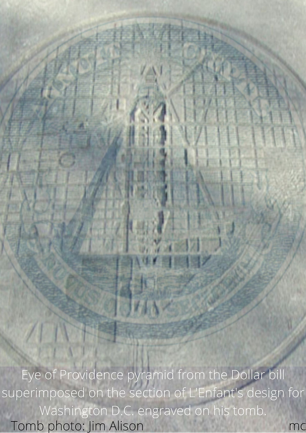
How curious that the design for the city of Washington should incorporate a pyramid, when the city itself is aligned with two Mexican sites both with one or several pyramids. These Jefferson / L'Enfant creations are fascinating, and reveal a penchant for hidden meaning, but they don't shed any light on my main question: was the site of the Capitol important before they arrived? I tried one last idea, which was to see if the Capitol linked up in any meaningful way with other sites of native inheritance in the USA, or even beyond. There's a very long-distance line from Heliopolis in Egypt that goes through a few interesting places including, in the DC area, the White House, the Lincoln Memorial and the Chaplain's Hill Monument in Arlington National Cemetery.
Also, a circle centered on Serpent Mound in Ohio goes through Chaplain's Hill monument in Arlington, the grounds of George Washington's Mount Vernon, and a few places near St Louis such as Cairo, Mounds Precinct, Wilson Mounds, Cleimen Mound and Village site, near Emerald Mound and Jon's mounds, then on north, very near Mound cemetery in Racine, on the shores of Lake Michigan.
Many mounds are to be found in the St Louis area in particular, which has the what was once the largest pre-Columbian settlement north of Mexico, the home of the Cahokia people.
Monk's Mound is roughly the same size as the Great Pyramid of Giza, according to Wikipedia, which says it "was calculated in 1988 as about 100 feet (30 m) high, 955 feet (291 m) long including the access ramp at the southern end, and 775 feet (236 m) wide." (5) French missionaries built a chapel at the entrance to the mound in 1735, and gave it the name, which suggests they understood the sacred nature of the place. I tried to find all the native American sites east of the Mississippi I could, placed them on Google Earth, then tried to find a logic to their locations relative to each other. I came up with these concentric circles. Washington D.C. is on a circle centered on Serpent Mound. The other circles in the diagram below are centered on Stone Mountain.

I also superimposed the concentric circles on Google Earth onto an old plan of the universe, showing the planets and the sun revolving around the earth..

You can see that Washington DC is on one of the circles centered on Serpent Mound, in Ohio, which also goes through, or near (to within about 2 miles) Mount Cemetery (Racine), Emerald Mound, Cleiman Mounds and and Wilson Mounds, Mounds Precinct, Mound City, Cairo, Wicklife Mounds, Etowah Indian Mounds. Also on this circle is the city of Richmond, Virginia, once an important town or city of the Powhatan Confederacy (Powhatan Hill).
Again, I went back to the site that would become Washington D.C.: was there anything there previous to the city, anything man-made? Nothing appears on any maps, anyway. I looked through many maps from the 18th century, thanks to the fantastic resources on the Library of Congress website, and found that the future District of Columbia area was just one among many not especially well mapped tributaries of the great Potowmac River that flows into Chesapeake Bay. There was nothing of interest there to any of the map-makers. However, that is not to say that there were no mounds or vestiges of a long-forgotten settlement. Maps from the same era of, say, Ireland, do not show the Hill of Tara or Newgrange. Still, what these maps do show is that, at first glance, there seems no obvious reason for building a great city there. The most notable natural feature of the future D.C area is perhaps the meeting of two rivers, the Potomac and the Eastern Branch, and the fact that downstream, the Potomac flows in a southerly direction, so that the confluence looks like a 'Y'. There would have been other places to consider for the site if that had been a factor, or the main factor. A city on the banks of the Bay of Chesapeake itself would have been magnificent. So what is the reason for the choice of this site?
Some samples from the maps I looked through, each showing the future D.C. area:
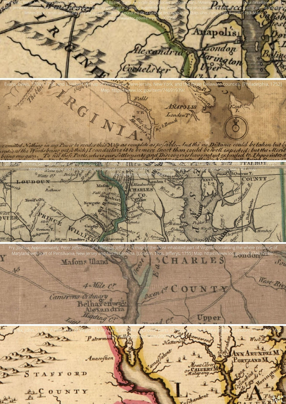
Compare to this Google Maps map, with Chesapeake Bay, Alexandria and Anapolis clearly marked:

Why did they not pick the already existing Alexandria or Anapolis? Anapolis was already an established town in Jefferson's time and in his memoirs he writes about departing from Anapolis to travel to Boston and Europe. Why didn't they go for the shores of Chesapeake Bay, which would have been both scenic and practical as a port? Perhaps a seemingly unremarkable site having been picked, not on the bay itself, or the coast, adds weight to the idea that it may have been chosen because it was on the line that links Cuicuilco, Teotihuacan, the Statue of Liberty, and Troy over in modern-day Turkey. I had to leave the question of the true history of Capitol hill as a mystery, with a few tantalizing clues but no real evidence of it ever having been a sacred spot, or a mound such as at St Louis. While there are many curious coincidences, it is hard to attribute such high-level surveying to either 18th century or pre-Columbian technological abilities.
One thing did strike me as possibly quite interesting when I took another look at L'Enfant's plans for the city: a peculiar stellar connection. Again, I looked back at all the maps I could find of the site before a single D.C street was ever built, and then the L'Enfant layout for the city. What they reveal is a desire for symbolism in the layout of the landscape.


Compare the plan above to Jim Alison's photo of l'Enfant's tomb: the pyramid which also features on the dollar bill is clear here, with the apex to the right and the base to the left.


The great advantage of looking at images on your mobile phone as opposed to your laptop is that you can easily turn them around. So I was looking at this map at this angle, with East facing up:

The smaller pyramidal shape, the one that corresponds to the dollar bill and that was visible on L'Enfant's tomb, links the Capitol and the back of the White house, and a point in the Potomac. The larger triangle marked out above with blue dots has the same base line but an apex further to the east. I have never been to Washington, and so I had no idea what the building at the top of this larger blue triangle that dominated the city was. I was surprised to find it was the site of both a prison and a hospital. I would have expected a palace or government building to be placed at the top of this huge Masonic compass. In size, the area at the top of this compass is comparable to the sites for the Capitol and the White House on this plan. The one other site with a huge space marked out is Lincoln Park, but no building was meant to be put there, according to this plan. It seems to be one of three, three main sites in the city. Was the layout similar to the pyramids at Giza, I wondered. I superimposed this plan onto a satellite image of the pyramids, but was disappointed to find the match was close but not good enough to merit any further attention. Then I thought I may as well try with the stars of Orion's Belt themselves. As you can see below, the match is pretty good. The three largest blue blobs match the locations for the White House, the Capitoal and the prison / hopsital site.
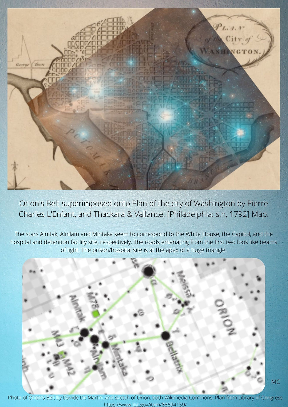
So it seems that the two triangles, the smaller one, shown on L'Enfant's tomb, with the Capitol for its apex, and the bigger one, with the prison / hospital site at the apex, are linked by this Orion's Belt pattern. Mintaka is the prison / hospital site, Alminam is the Capitol, and Alnitak is the White House.
The Orion correlation theory was put forward by Robert Bauval in the late 80s, and suggests that the pyramids of Giza are laid out so as to represent the three stars of Orion's Belt. It is an idea that has generated huge interest and many responses. A huge part of the discussion is centered on the exact arrangement of these stars and their counterparts here on Earth at Giza, and what this tells us of the possible date the pyramids were designed. Robert Bauval and Graham Hancock worked together to suggest that in 10,500 BC, the angles between a line linking the three stars of Orion's Belt and the horizon was an exact match to the angles between the three main Giza pyramids and the Earth's coordinates. Again, we have a possible link to pyramids, this time however not with Mexican ones but with Egypt.
So it seems that possibly the three stars of Orion's Belt may have been present in the design for the city, with Mintaka marking the apex of the great eastward pointing triangle that is the backbone of the city. It wasn't what I was looking for, but it was perhaps at least another clue as to a prior native American layout, marked out by mounds. Or perhaps it was just L'Enfant's brilliance.
Is the Capitol on a once sacred spot, important to the Native American people who lived there before the Europeans? Clearly, the destruction of most traces of Native American civilisation was so great in the United States over the centuries that it is difficult to find anything. Because so many of the indigenous population died, their traditions and stories died too. After all, entire pre-Columbian cities were razed to the ground in the States. And there is not a hope that any excavations could be made under the Capitol today. But there are just a few tantalizing clues that maybe, just maybe, this site was important once, long ago, to an entirely different people, who have been consistently underestimated and overlooked.
Notes
1. Archaeology of Native North America by Dean R. Snow
2. "A Native American tribe once called D.C. home.", Washington Post, Dana Hedgpeth, October 22, 2018.
3. Proudfit, Samuel Vincent (1889). "Ancient Village Sites and Aboriginal Workshops in the District of Columbia". American Anthropologist. The Aborigines of the District of Columbia and the Lower Potomac - A Symposium, under the Direction of the Vice President of Section D. 2 (3): 243. ISSN0002-7294. JSTOR658373. Retrieved 2020-10-11 – via JSTOR.
4. "Before the White House", by Lina Mann, September 26, 2019, Before the White House - White House Historical Association (whitehousehistory.org)
5. Skele, Mike "The Great Knob", Studies in Illinois Archaeology, no. 4, Springfield, IL, Illinois Historic Preservation Agency (1988) ISBN 0942579038, pp. 1–3, via archive.org
6. See Jim Alison's work here: Untitled Document (hiwaay.net)


Hi Mat,
Sorry to hear you're being distracted from your work! 😅
Thank you so much for your comments and suggestions. I don't have any of these sites on my Google Earth. They do fit the Troy line very well. Castle Neroche looks like an interesting site. When I placed it on Google Earth, I saw it was very close to a couple of lines running nearby. My Google Earth is chaos, lines everywhere, it looks like one of those rubber band balls! I clicked on one of the lines to see what it was, and it seems Castle Neroche is the same distance from a site called St Michael's Hill, in the village of Montacute in Somerset, as are…
Hello Melissa, I've found some interesting, if somewhat less significant locations on your Troy tract.
Castle Neroche: A Norman motte-and-bailey castle built on the site of a Bronze Age hillfort in Somerset.
Mockham Down Camp Hillfort:
Iron Age Hillfort in North Devon, the Troy tract passes directly through the centre.
Tracks Suzuki, Blagdon Somerset:
I still get my car serviced here even though I moved to Malvern not long ago. Lissacresig:
A ringfort in County Cork circa AD 550–900. A number of interesting older sites are in close proximity including stone circles.
?????: I can't find any info on this one, but it's less than 4km East-South-East from Lissacresig. Another ringfort? Your incredible website is distracting me from my work!!! Take care, Mat (Apocalypse).